Keep downtopc Online Please

Categories
PREMIUM ACCOUNTS
Support downtopc by buying or renewing your premium account using below links:


Most Commented

![eM Client Pro 9.2.1735 Multilingual [Updated]](https://pikky.net/medium/wXgc.png)
Partners


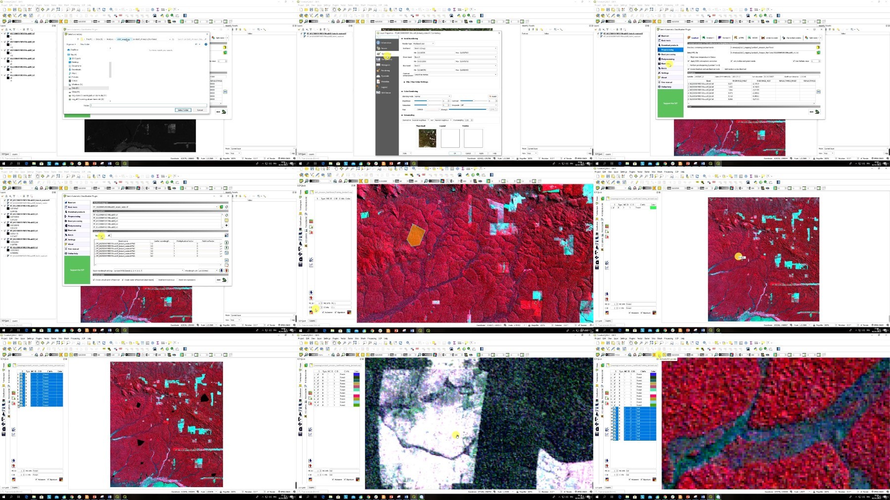
Udemy - Machine Learning in Spatial Analysis GIS & Remote Sensing


Description material

Download Free Download : Udemy - Machine Learning in Spatial Analysis GIS & Remote Sensing
mp4 | Video: h264,1280X720 | Audio: AAC, 44.1 KHz
Genre:eLearning | Language: English | Size:2.86 GB
Files Included :
1 Introduction.mp4 (13.95 MB)
MP4
2 GIS explained.mp4 (31.55 MB)
MP4
3 Introduction to Remote Sensing definition.mp4 (24.59 MB)
MP4
4 Introduction to Remote Sensing applications.mp4 (80.88 MB)
MP4
1 Computer Set up for GIS analysis and GIS software on the market.mp4 (68.52 MB)
MP4
2 Installing QGIS.mp4 (86.77 MB)
MP4
3 Exploring QGIS interface.mp4 (155.09 MB)
MP4
4 A power of QGIS - QGIS Plug-ins.mp4 (99.63 MB)
MP4
5 Lab Sign In to Google Earth Engine.mp4 (45.67 MB)
MP4
1 Introduction to Machine Learning.mp4 (93.51 MB)
MP4
2 On Machine Learning in GIS and Remote Sensing.mp4 (51.12 MB)
MP4
3 OTB installation.mp4 (10.93 MB)
MP4
1 Supervised and Unsupervised Learning (classification) in GIS and Remote Sensing.mp4 (71.42 MB)
MP4
2 Unsupervised (K-means) image analysis in QGIS.mp4 (58.83 MB)
MP4
3 Random Forest supervised classification of Sentinel-2 image.mp4 (248.84 MB)
MP4
4 Decision Trees classification of Sentinel-2 image.mp4 (209.98 MB)
MP4
5 Accuracy Assessment.mp4 (50.97 MB)
MP4
1 Extra Training data collection for image classification based on Landsat images.mp4 (309.26 MB)
MP4
2 Lab image classification in QGIS.mp4 (48.06 MB)
MP4
1 Supervised classification with Google Earth Engine.mp4 (271.17 MB)
MP4
2 Import images and their visualization in Google Earth Engine.mp4 (141.91 MB)
MP4
3 Unsupervised (K-means) image analysis in Google Earth Engine.mp4 (103.76 MB)
MP4
1 Object detection in GIS.mp4 (37.33 MB)
MP4
2 Segmentation and object-based image analysis (OBIA).mp4 (51.47 MB)
MP4
3 Segmentation of high-resolution satellite image.mp4 (141.26 MB)
MP4
1 On regression in GIS.mp4 (29.27 MB)
MP4
2 ArcGIS Software for regression analysis.mp4 (21.84 MB)
MP4
3 Lab Use regression analysis in ArcGIS.mp4 (166.03 MB)
MP4
4 Prediction in GIS and deep learning for Big Data Analysis.mp4 (39.08 MB)
MP4
1 Project assignment.mp4 (70.2 MB)
MP4
2 BONUS.mp4 (5.92 MB)
MP4
https://rapidgator.net/file/3ca3909b40e01c049d81e7a1ea0f1e0f/.Machine.Learning.in.Spatial.Analysis.GIS..Remote.Sensing.part1.rar
https://rapidgator.net/file/b3d127202df0296b993c4f6944baf4b5/.Machine.Learning.in.Spatial.Analysis.GIS..Remote.Sensing.part2.rar

https://katfile.com/qjr8cp0oqzu4/.Machine.Learning.in.Spatial.Analysis.GIS..Remote.Sensing.part1.rar
https://katfile.com/yuhzno78x8l6/.Machine.Learning.in.Spatial.Analysis.GIS..Remote.Sensing.part2.rar
Free search engine download: Udemy - Machine Learning in Spatial Analysis GIS & Remote Sensing
Join to our telegram Group
Information
Users of Guests are not allowed to comment this publication.
Users of Guests are not allowed to comment this publication.
Choose Site Language
Keep downtopc Online Please
PREMIUM ACCOUNTS
Support downtopc by buying or renewing your premium account using below links:
Recommended news


Commented
![Movavi Video Editor 24.0.2.0 Multilingual [ Updated]](https://pikky.net/medium/qhrc.png)


All files on the site are presented for informational purposes.
Copyright © 2025 - Downtopc | All rights reserved