Most Commented
Picture Instruments Smart GPS Sync Pro 2.0.10 macOS


Description material

File Size: 19 MB
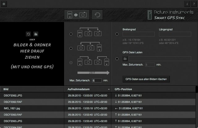
You don't want to do without GPS-tags in your photos but you also don't want to run a GPS-logger all the time? If you take just one single photo containing GPS data with your smartphone you can use "Smart GPS Sync" to transfer that GPS information to all other photos in your camera at a later point in time.
If you have no photo with the right GPS data at hand you can also just copy longitude and latitude from Google Maps or Bing Maps into the corresponding fields and apply them to an entire batch of photos. This is especially helpful for on-location and event photography where not every photo is shot at a new location. This method is also greatly helpful if you occasionally want to add geodata to a photo.
If you are on a photo trip you can conveniently have a GPS-logger run along (for instance in a smartphone or in an outdoor GPS device) and record a .gpx track. In the evening you can simply load the .gpx file as well as all photos of the day into Smart GPS Sync and the software will add the corresponding GPS information into every single photo.*
Features
- Transfers the GPS data from one photo to any number of photos
- Writes latitude and longitude information directly into the EXIF data of photos (even for RAWs which means that NO separate XMP file is created)
- Geotagging with or without GPS logger
- Is able to remove GPS information from photos
- Simple transfer of GPS-data from a .gpx file to any number of photos *
- Recognises tracks and waypoints in GPX files *
Supported File Formats :
3g2 , 3gp , 3gp2 , 3gpp , aax , ai , ait , apng , arw , ciff , cr2 , crw , cs1 , dcp , dng , dr4 , dvb , eps , eps2 , eps3 , epsf , erf , exif , exv , f4a , f4b , f4p , f4v , fff , flif , gif , hdp , icc , icm , iiq , ind , indd , indt , inx , j2k , jng , jp2 , jpe , jpeg , jpf , jpg , jpm , jpx , jxr , m4a , m4b , m4p , m4v , mef , mie , mng , mos , mov , mp4 , mpo , mqv , mrw , nef , nrw , orf , pbm , pdf , pef , pgm , png , ppm , ps , ps2 , ps3 , psb , psd , psdt , qt , raf , raw , rw2 , rwl , sr2 , srw , thm , tif , tiff , vrd , wdp , x3f , xmp
* The GPX sync feature is only available in version 2 (pro). Owner of a version 1 (basic) license can buy the upgrade for using the GPX sync feature. Alternatively V1 owner can use the V2 as a basic version without the GPX feature by just installing the V2 application.
Supported Operation Systems
macOS 10.10 or later
Screen :

What's New
Updates: official site does not provide any info about changes in this version
HOMEPAGE
https://www.picture-instruments.com

Warning! You are not allowed to view this text.Warning! You are not allowed to view this text.
Join to our telegram Group
Information
Users of Guests are not allowed to comment this publication.
Users of Guests are not allowed to comment this publication.
Choose Site Language
Recommended news
Commented


![eM Client Pro 9.2.1735 Multilingual [Updated]](https://pikky.net/medium/wXgc.png)


![Movavi Video Editor 24.0.2.0 Multilingual [ Updated]](https://pikky.net/medium/qhrc.png)

