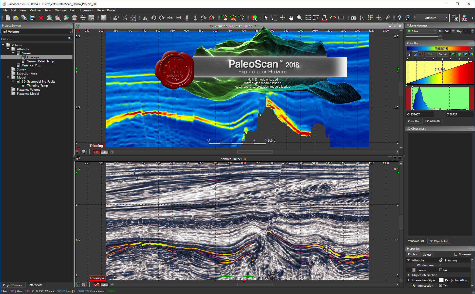
At the confluence of powerful algorithms, computational power and data analysis, our revolutionary technology pushes your seismic interpretation to an unprecedented level. We can deliver a substantial qualitative and quantitative change to E&P businesses by creating new opportunities for energy supply enhancement, reducing risk and making timely and enlightened decisions.
Stay ahead of the curve with our new generation of 2D/3D seismic interpretation platforms!Strengthen your seismic interpretation potential, integrate all available data and develop your creativity.
Running on Windows®, our platform offers a great panel of E&P workflows from basin-scale evaluation to prospect maturation. It includes our first-class automated horizon tracking step and the associated supervised Relative Geological Time model, and our fully automated fault extraction tool . just to quote a few!
Our intuitive interface coupled with an embedded cross-correlation tool dramatically increases your screening capacity, enables better predictions, and triggers early stage sweet spotting. In addition, powerful editing and visualizing tools help to refine the interpretation and perform real-time preview on the iterative Relative Geological Time model creation process.
PaleoScan™ Core Application suite empowers you to-Generate a large panel of seismic attributes
-Convert all seismic reflectors into Horizons
-Model an unlimited number of stratal slices
-Emphasize and model faults and fractures
-Extract and classify geobodies
-Cross-correlate well logs and well markers with any attribute
Advanced interpretation extension-Navigate between your structural and wheeler domains in real time
-Delineate key stratigraphic surfaces and model 3D systems tracts
-Automatically extract geobodies
-Convert stratigraphic units into a reservoir grid
-Reveal geomorphologies through our data blending methods
Time-Depth extension-Perform seismic to well tie with a forward modelling workflow to compute a synthetic model in real time
-Generate accurate velocity models, then carry out detailed domain conversion
Property modelling extension-Propagate rock physics from hard data through your RGT model and build electrofacies models
System RequirementsOS:64-bit Windows® 7/8/10
Memory:6 GB RAM
CPU:4-core/6-core
GPU:Graphical card ATI Radeon or NVidia GeForce 512Mo
Screen : What's New
New Features
-FAST™ streaming Local VDS - New VDS FAST™ option added to stream VDS files stored locally
-FAST™ streaming Remote VDS - New VDS FAST™ option added to stream VDS files stored on the Cloud
-VDS volume Import - New option to import VDS volume in PaleoScan™ using OpenVDS API
-VDS volume Export - New option to export volume as VDS file from PaleoScan™ using OpenVDS API
-Well Import - Well Database update is handled at the import (for ascii, shapefile and LAS formats): conflict management enhanced for Well ID (UWI), Well Status and Well Spatial Unit with info logged in Message Window
-Well Set - New Well set object added to organize the wells from the Project Browser. It can be created from the Project Browser and wells can be drag and dropped
-Well Data Manager - Well Data Manager is a non-modal window for viewing and editing wellhead data
-Wellhead data - Well ID (UWI), Original Spatial Unit, Well Status and Well Color are now handled in the PaleoScan™ application. Status is defined on wells (at the import, with a cross-reference mechanism and/or in -the 'Well/Log Table' and 'Well Data Manager') with associated symbols for 2D viewers and tools. A sorting by name or status is available for the wells in the Project Browser
-Model-Grid Creation - New polarity parameter was added to compute Peak, Trough, Zero Crossing and Inflexion -Point and increase the vertical resolution
-Model-Grid Creation - Patch size upper limit was set to 1 to allow better interpret complex geometries
-Model-Grid Display - Polarities can have specific colors and updated from Properties or Settings
-Model-Grid Display - Polarities visualization can now be filtered from the Properties
-Model-Grid Horizon List - New pop-out option implemented to extract the Horizon list from PaleoScan™
-Model-Grid Horizon List - New interface to display Horizon list filtering options in a ribbon and new icons update
-Model-Grid Horizon List - Maximum number of displayed horizons was increased
-Model-Grid Horizon List - Filtering area can be done with minimum and maximum values
-Model-Grid Horizon List - Histogram added in the filtering ribbon to show the range area of the filtered horizons
-Model-Grid Horizon List - Enabling horizons multiselection from the horizon list with link to the context menu options
-Model-Grid Horizon List - Horizon under editing highlighted in the Horizon List
-Model-Grid Horizon List - New column added to show Last edition date for the horizons
-Model-Grid Horizon List - New Auto-update option in the Horizon list to automaticlly update horizon list while editing
-Model-Grid Horizon List - New option in the context menu of the Horizon list to create Horizon Stacks from Horizons
-Model-Grid Horizon export - Naming of the exported horizons is now more consistent
-Horizon Picking - New display for picked horizon with color of the picking changed following the picking method
Maintenance
-2D Horizon Stack - Fix crash during creation from 2D Horizons
-2D Horizon - Fix decimation during export
-2D Horizon - Speedup dialog opening during export
-2D Attribute - Fix color bar assigned to created line
-2D Attribute - Fix missing refresh of the project browser after object creation
-3D Attribute - Fix structure oriented smooth preview
-Sequence Stratigraphy - Fix crash while deleting sequence
-Units - Conversion factor for PaleoScan™ units is fixed
-Interface - Display of the wells list in the pull-down menu is improved for the following dialogs: Well/Log -Table, Composite log creation, Extended Elastic Impedance workflow, Well Marker QC, Wavelet creation, Log Set -Merging, Sonic Calibration, Seismic Well Tie
-Project Opening - Project management on remote drive improved to avoid data corruption
-FAST™ streaming - FAST™ streaming window is more stable and does not freeze when FAST™ service is down
-Horizon Import - Fix instability when importing and overwriting 2D horizons
-Well Head Import - Wellhead import interface improved
-Well data Import - Bug fixed on the management of the Well trajectory unit at the import
-Well data Import - Functionality of Log import with CRS is fixed. Management of errors and warnings at import of well data is improved
-Well data Import - LAS import is more stable and does not crash
-Well/Log Table - Minor bug fixed on the default tab displayed in Well/Log Table dialog
-Log Viewer - Bug fixed on the multi-selection of curves in the same track
-Log Viewer - Bug fixed on the persistence of the display settings of the Header Viewer
-Wells - Properties tabs split into display and object properties
-Wells - Well conversion to project CRS is fixed
-Wells - Reduce time load for large number of wellhead when opening or browsing a project. Improved performance at the import and for visualization
-Wells - Well object properties (accessible when well is selected from the Project Browser) is split into Display tab and Object tab
-Wells - Reference Elevation scheme is added in the KB tooltip (available from Well Import dialogs, Well/Log Table and Well Data Manager)
-Wells - Wellhead spatial unit is connected to the PaleoScan™ settings for display consistency
-Wells - The tool Choose Well Set to Apply layout filters only wells containing log set
-Wells - The tool Create TWT and depth log creation filters only wells containing log set
-Well Marker - Well QC tool filters only wells containing marker set
-Seismic-Well Tie - Sonic Calibration and Seismic Well Tie tools filters only wells containing log set
-Velocity Modeling - The pixel at the start is no more influenced by the Output Step modification for: Domain Conversion, Dix or RMS volume computation
-Color Bar - Fix issue on the Color Bar when using the Contouring option on the Horizon Stack
-Properties - Improved object visualization by always showing Display tab parameters instead of Properties
-properties - Performance improved when updating Properties for Volume Attribute on 2D Line Viewer
-Settings - Icon display on Dark mode was improved
-Settings - Application Style selection re-enabled at the start of the application
-Horizon - Ghost usage for horizon picking is more stable
-Horizon - Fix crash when dragging horizon to viewer
-Horizon - Fix assignment of contouring step in Horizon viewer properties
-Horizon Stack - Special characters such as + sign is now allowed for 2D and 3D Horizon Stack naming
-Volume - Coordinate Editor preview pane was reviewed to display and locate all coodinate points
-Volume - Error message refering to intersection was fixed when using Volume Extraction tool
-Volume - Scrolling in 2D viewer no more refresh properties view
-Strati Viewer - Fix crash on Strati Viewer when using Cancel button on Edit/Save Velocity Model tool
-Model-Grid - Fix crash when using undo/redo operation on the Model-Grid
-Model-Grid - Fix crash when opening the Model-Grid Constraint window
-Model-Grid - Fix a crash while using corrupted horizon to constraint a Model-Grid
-Model-Grid - Improved patch creation for Inflexion Points polarity computation
-Model-Grid - Option "Respect Locked Path" is now a checkbox
-3D Model-Grid - Fix crash due to lack of allocated memory for the Model-grid computation on a large dataset
-2D Model-Grid - Fix crash on the Model-grid computation on a large 2D Line Set
GeoModel Preview - Issue on the refresh of the GeoModel Preview was fixed when updating Quality parameter
-Fault Editing - Anchor point edition is working and can be edited
-Fault - Forbid special characters in object name and prevent export
-2D Line - Fix crash on transfer of 2D Line from Petrel® to PaleoScan™
-2D Line - Fix crash while removing object from 3D viewer
-2D Line Set - Improve title of intersection viewer
-2D Line Set - Fix navigation between lines during creation of a 2D Line Set
-Wavelet - Fix deterministic wavelet creation with Roy white algorithm
-Project - More reliable way of saving XML files in PaleoScan™ project
-Session - Well ID (UWI), Well Status, Well Color and their corresponding parameters in Properties tab are saved in PaleoScan™ sessions
-OpenWorks® - Well data units transfer is fixed
-OpenWorks® - Fix issue on incorrect unit transfer for well trajectory during the transfer from OpenWorks® to -PaleoScan™. Now if the unit is in feet, it is correctly used in PaleoScan™
HOMEPAGE
https://www.eliis-geo.com/
Buy Premium Account From My Download Links & Get Fastest Speed.


![eM Client Pro 9.2.1735 Multilingual [Updated]](https://pikky.net/medium/wXgc.png)


![Movavi Video Editor 24.0.2.0 Multilingual [ Updated]](https://pikky.net/medium/qhrc.png)

